

Photo by Justin Sullivan/Getty Images
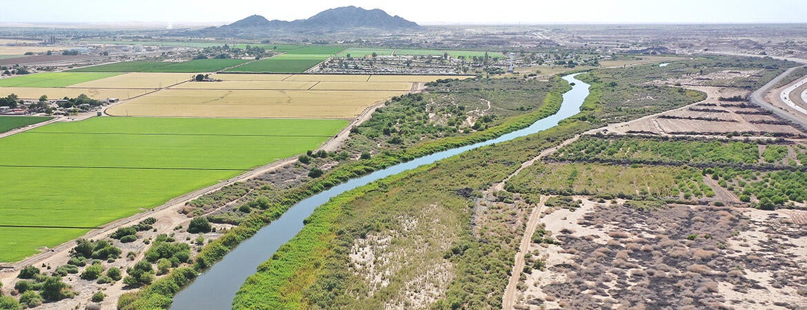
The Colorado River is a lifeblood for the U.S. Southwest that provides tap water for some 40 million people and irrigation for 2.6 million acres of crops in seven states and Mexico.
But as water flows decline with climate change and a century-old water rights accord becomes unsustainable, federal, state, and local policymakers with competing interests find themselves in a political cauldron with nothing but tough choices.
UC Riverside public policy scholars, however, are bringing clarity to a fraught debate. They have created a hydro-economic model that can illuminate the future impacts of major water use changes by answering prompts and clicking a mouse. UCR's School of Public Policy has published a working paper describing the framework of the model, which is expected to be publicly available online early next year.
What would happen, for example, to crop production should a greater proportion of the water be diverted from agriculture to cities? The model can detail the benefits to cities and impacts to agriculture, such as reduced planted acreage or switches to more water-efficient crops and technologies.
What would it mean for carbon-free, hydroelectric production if water flows dropped to the point where Glen Canyon Dam in Arizona had to be bypassed so the Hoover Dam some 277 miles to the south would have enough water flow to keep its electrical turbines going? The model would detail the loss of megawatt hours and the corresponding economic costs to the basin.
And what would it mean for cities and agriculture if water flows dropped but water managers maintained current flows allocated for wetlands and other wildlife habitats? The model details the impacts on cities and farms.

For these scenarios and many more, the hydro-economic model will provide objective answers. It was developed by UCR School of Public Policy postdoctoral scholar Daniel Crespo, assistant professor Mehdi Nemati, and distinguished professor Ariel Dinar, in collaboration with Zach Frankel and Nick Halberg of the Utah Rivers Council.
By showing hypothetic impacts to cities, states, tribes, farmers, and wildlife conservation, the model also allows for consideration of “out of the box solutions that right now many stakeholders don’t even want to mention,” Dinar said.
Water allocations to seven states, for instance, are still governed by the 1922 Colorado River Compact, which was signed during high water flow year and never envisioned water volume declines from climate change. The 1922 high flow level has occurred during less than 40% of the years since and in only one year since 2000.

“Nobody wants even to think about changing the parameters of the 1922 treaty,” Dinar said. “A model like what we developed will allow us to check different options under different scenarios of climate change, and there may be some very reasonable solutions.”
Policymakers will be able to quickly assess the costs and benefits of increasing water use efficiencies, such as installing drip irrigation on farms, increasing water-wise landscaping in cities, and moving canals to underground to reduce water losses from evaporation, Nemati said.
The authors of the working paper that details the framework and scope of the model are now seeking input from irrigation and urban water managers, as well as various other stakeholders.
“The vision was from the beginning to put a big picture together,” Nemati said. “This becomes complex, but at the same time, we want to see the relative costs and benefits as we go from here to there, rather than just focusing on one specific region.”
Crespo added that the model will provide information about the vulnerabilities of the water system, and how it can be resilient.
“We have to understand that we have a future with climate change and population growth on our heels with deep uncertainties,” Crespo said. “We must provide information about policies that are robust, flexible, and strong, and they have a capacity to provide resiliency to the system.
“This model can do all these things.”